Terrapin X - LR/ELR performance test
After very long wait, we were finally able to test new TerrapinX properly- with practical size shooting target.
Disclaimer - as usually, we do apologize following article typos and even errors in advance. This too is written in rush between thousand other things going on and English is not our native language. Bear with us please.
Terrapin X was already promising during previous day testing, test done in open field with barns, wood line and windmills. Terrapin went up to 2390m without too much effort (see vid in end), even in rather challenging light conditions: sun was behind and relatively low.
As prefix- Terrapin X has sensors which were available earlier only in mil-series PLRF-10C and above- costing easily over 5000€ not many years ago. Terrapin X has compass and inclinometer integrated as standard feature. Compass was benchmarked against high-quality Suunto traditional compass: Terrapin magnetic north azimuth had less than 6 degree difference compared to Suunto. Terrapin X has also manual declination correction for true north. -Edit 6.6.2018: I did not calibrate Terrapin compass at all. Device can be manually calibrated for best precision, so more than likely accuracy would have been better in my test unit too. Compass does not require new calibration until new battery has to be changed.-
Inclination was compared against digital inclinometer using Terrapin housing tripod surface as reference. Terrapin was again within spec, showing less than 1 degree difference compared stand-alone digital inclinometer. Terrapin housing is fully rubber armored, and it has 1/4 camera thread as standard option. Comes also with strap, pouch and CR123 battery feeding 4000 measurements.
So all set so far.
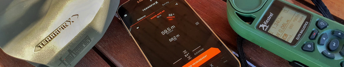
Unlike older military PLRF Vectronix lasers with compass, Terrapin X can communicate wirelessly with external devices too. Connected external device can be mobile phone, tablet or Kestel ballistic computer supporting Kestrel LiNK Bluetooth protocol. I tried connection to both Kestrel 5700 Elite and Vectronix Android remote-use app, both worked fine. As Terrapin is connected to Kestrel, it sends each measurement results to ballistic computer automatically and after each successful measurement. Range, uphill/downhill angle and target compass direction appear on Kestrel Elite in a second after measurement- and Kestrel calculates ballistic solution for this measured target instantly. Handy!
Terrapin phone app can be used as remote trigger, or to see measured values from phone "remote display". Communication is 2-way, so both devices show same values all times, it does not matter if measurement trigger is given from phone or by Terrapin housing button. Terrapin App can also update firmware inside Terrapin X if needed- a must feature in any modern device with complicated software inside. Vectronix App informs owner/user automatically whenever new FW is available, updating of Terrapin requires only a tap with a finger and 1-2 minutes waiting. It doesn't get much easier than this: no plugging to PC, no swearing with serial port drivers or any other annoying drills needed whatsoever. Android App can also set range gate in Terrapin, not too often needed feature but at least good to set it for starters. This blocks false reflections from bushes/vegetation often found on front of prone firing point.
To fields!
More realistic target was used this second test trip: 17.7"/45cm wide and about 28"/70cm tall aluminum plate, equaling average torso size exactly. Plate was not glossy but still with good reflectivity. Sun was again in challenging position, directly behind and very low too. As my personal wireless target camera system -the Mighty Swarovski STX with 95mm objective and 120x ME1.7 magnifier- was in trunk, thought to try its resolution same time with A4 reference table. Stored also target location to GPS, 20 found satellite (GPS + Glonass) coverage pinpointed spot nicely.
Da plate. Note treeline behind 358m/392yds further, it was pinged too.

Measurements were made in three points: 1121m, 1507m and 2007m. (1226yds, 1648yds, 2195yds). Terrapin gave range with first press of button each time- and this was a pleasant surprise. Also range to wood line behind was measured with first try for 2 closer ranges, but not at all for furthest- it would have been about 2400m or 2625yds. Ranges to wood line from closer 2 points were 1479m and 1863m (1617yds, 2037yds), these both came trough with first try. So Terrapin X performed truly well. Furthest 2007m/2195yds) target was in very limit- I was able to get range only twice. With very first try - and after 20...30 presses, only once later. Best guess is that rather heavy mirage blurring target simply did not allow more range, I just happened to get trough at just enough calm moment. Sun direction and angle did not help either.
Mirage as seen from 1121m/1226yds - Taken with Swarovski STX95 @120x

First 1121m/1226yds point. 1479m/1617yds to wood line, both measured with first press of a button- as was the case in 1507m/1648yds plate and 1863m/2037yds wood line too. Tiny white spot under fingertip is plate and rack. This point btw was just next to Curlev's nest, upset and somewhat aggressive mother was keeping me noisy company. Livin on the edge for our customers!

Longest and final range- 2007m / 2195yds to plate under fingertip. Ranged with first try, then difficulties to repeat it. Ranged distance difference 10m or less to GPS position, although non-differential GPS is really not reliable anyway if "few meters" resolution is required. Note tripod shadow length and direction: Low sun, directly behind.

Plate and rack inside Terrapin aiming circle, little right and low. Laser beam is aligned with circle perfectly- and is also very very close to same size than circle center open area is: in order to get measurement, plate had to be inside aiming mark. Terrapin image quality is very good.

All in all, we are positively surprised. Vectronix did it again! Device is well designed, starting from packaging and ending to Android application. It simply performs very well in all aspects, not leaving much to desire for any LR/ELR shooter.
In same spot from where 2007m photos were taken, I was able to scan almost 180 dec sector. Barns and all other other visible buildings from 900m to +2300m: no problems really to measure any of them except beyond 1900m or so couple of measurements is sometimes needed. Treelines, bushes etc, 1400...1800m results all day long depending about shape, size and type. Horses and cows from 700m to 1000m and over, all measured and also with first try. Longest range I managed to catch came from woodline, 2775m, but could not duplicate it. Exact spot was lost, did quick panning with constant trigger.
Tried unit with serial 00002 is not final production version, but is practically same. Hard to come up with any bad sides really. Well, it is not cheap - but no need to sell kidney either. Or update to better laser, some time later after purchase.
Estimated arrival of first production batch is during summer, pre-orders are accepted already. It is available in our webshop already. Swedish, Norwegian and Danish customers can get theirs from official Terrapin country representatives from www.jakt.se, www.langhold.no and www.koskov.dk
Previous day test - barns and windmills:
1 comment
Hello,
I would like to know if it’s possible to export all the measurements of one day (for example in .csv, excel or .txt file) from the application or by connecting the terrapin directly to a computer without the application or if we can only see the last measurement.
Thank you very much
Astrance Fenestraz